Forests can be risky climate investments to offset greenhouse gas emissions

Mega-fires raged across the Northwest Territories, Canada in 2014, driven by record breaking hot, dry conditions (territorial government photo)

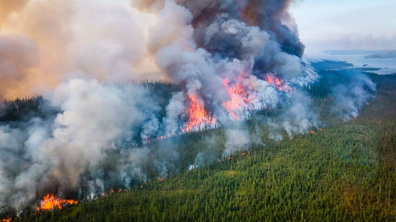
Given the tremendous ability of forests to absorb carbon dioxide from the atmosphere, some governments are counting on planted forests as offsets for greenhouse gas emissions—a sort of climate investment. As with any investment, however, it’s important to understand the risks. If a forest goes bust—through severe droughts or wildfires, researchers say—much of that stored carbon could go up in smoke.

There have been optimistic assessments of how valuable forests could be in mitigating climate change over coming decades, but all of those have somewhat surprisingly overlooked or underestimated the factors that constrain forest carbon sequestration in the face of extreme temperatures, drought, fire and insect disturbance

Scott Goetz

Professor Scott Goetz of Northern Arizona University’s School of Informatics, Computing, and Cyber Systems and associate professor Deborah Huntzinger of NAU’s School of Earth and Sustainability co-authored a paper published in Science finding that forests can be best deployed in the fight against climate change with a proper understanding of the risks to forests that climate change itself imposes.

Built into forest-based natural climate strategies is the idea that forests are able to store carbon for at least 50 to 100 years. Such permanence is not always a given, with the very real chance that the carbon stored in forest mitigation projects could go up in flames or be lost due to insect infestations, severe drought or hurricanes in the coming decades.

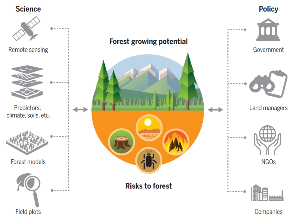
The paper’s authors encourage scientists to focus increased attention on assessing forest climate risks and share the best of their data and predictive models with policymakers so that climate strategies including forests can have the best long-term impact. For example, the climate models that scientists use are detailed and cutting-edge, but aren’t widely used outside the scientific community, so policymakers might be relying on science that is decades old.

Good science can better help identify and quantify risks to forest carbon stocks and lead to better policy decisions

Deborah Huntzinger

… Continue reading at NAU News

… Head straight to the Science

A warming Arctic turns topsy turvy

Clouds obscure Yellowknife and Great Slave Lake in Canada’s Northwest Territories. The ABoVE team is studying approximately 4 million square kilometers (more than 1.5 million square miles) of northwestern North America, spanning from Canada’s Hudson Bay to Alaska’s Seward Peninsula. Credit: NASA/JPL-Caltech

Last summer was hot in Alaska.

How hot was it, you ask?

Well, last summer was so hot, salmon were literally cooking themselves in the rivers.

Bad joke? Perhaps. While you won’t find river-boiled salmon on the menu at your local seafood restaurant anytime soon, it’s a fact that last July, as Alaska and much of the Arctic experienced near-record warmth, the water temperature in some Alaskan rivers reached an unfathomable 82 degrees Fahrenheit (28 degrees Celsius). The abnormally warm waters led to mass salmon die-offs.

Sadly, the fate of the simmering salmon, while exaggerated, stems from a disturbing reality. As the Arctic warms three times faster than the rest of our planet, this excess heat is taking an increasingly severe toll on Arctic ecosystems and Earth’s climate.

Ask Chip Miller. The NASA Jet Propulsion Laboratory atmospheric scientist has spent much of the past decade crisscrossing Alaska and Canada as a lead scientist on two NASA airborne field campaigns: The Carbon in Arctic Reservoirs Vulnerability Experiment (CARVE) and the Arctic Boreal Vulnerability Experiment (ABoVE).

Read on to explore how airborne remote sensing helps Arctic and Boreal scientists understand permafrost, wildfires, caribou, methane hotspots, biome shifts and much more…

Chip Miller, ABoVE airborne lead scientist, shares his experiences from thousands of meters up, and GEODE/ABoVE science lead Scott Goetz describes a northward march of shrubs.

GEODE PhD student Katie Orndahl awarded NAU’s Most Promising Graduate Student Research Scholar

Katie records plant species cover while conducting field work in the Yukon Territory, Canada

Each year the NAU Office of the President and the Office of the Vice President for Research present a series of Research and Creative Activity Awards.

This year, GEODE PhD student Katie Orndahl was awarded NAU’s Most Promising Graduate Student Research Scholar.

This award is given to a graduate student “who has displayed excellence in research and scholarship, and demonstrated significant potential for further success in his/her discipline.”

Nine ‘tipping points’ that could be triggered by climate change

Infographic by Rosamund Pearce & Tom Prater

Imagine an Earth system component, such as an ice sheet, circulation pattern or ecosystem, as a game of Jenga.

As global temperatures gradually rise, block after block is removed from the base of the tower and placed on top. The tower becomes more and more unstable, until at some point, it can no longer support itself and it topples over.

These are the mechanics behind climate tipping points . The cumulative impact of changes to the Earth system can push the system over a tipping point — a point after which serious and irreversible changes are inevitable.

GEODE lead Scott Goetz reflects on one of nine potential climate tipping points in a new article by Carbon Brief.

“An example of a tipping point in boreal forests is a situation where an extreme fire event or repeated severe events render the system incapable of regenerating as a forest ecosystem and instead shifts the system to a sparsely wooded or grassland ecosystem.”

Read more about boreal forest shift, and the other 8 tipping points, here.

A world map showing the locations of boreal forests. Credit: aroderick / Alamy Stock Vector

NAU scientists help chart a path to understand how Arctic vegetation is changing

“We’re confident the Arctic is greening, but we want to do a better job incorporating new satellite and drone remote sensing data with field measurements to understand where, why and how vegetation is changing across the Arctic domain.” — Logan Berner

New research published in Nature Climate Change  brings together remote sensing scientists and field ecologists to provide a better understanding of how vegetation is changing throughout the Arctic.

GEODE lead Scott Goetz and assistant research professor Logan Berner collaborated with 38 other co-authors to lay out a research framework to better characterize how vegetation changes vary across space and time and among various satellite data sets, as well as how the changes are interpreted and integrated with field measurements.

“The aim of this research is ultimately to understand how satellites can provide better information on how much carbon is being removed from the atmosphere by Arctic vegetation relative to how much carbon is being released through permafrost thawing and fire. What is mitigating additional warming and what is exacerbating additional warming?” — Scott Goetz

Read the full article: Complexity revealed in the greening of the Arctic, or coverage from NAU News

When a road leads to deforestation…

A spider web of roads stretches across central Africa

After driving through the Congo rainforest for half a day, researcher Fritz Kleinschroth hopped out of the pick-up truck to find more than a dozen butterflies caught in the front radiator grille. The butterflies varied in orange, red, white, and blue, representing just a sliver of the diversity of insects and wildlife living in the Congo Basin. The driver of the logging truck was less focused on the butterflies and more enthusiastic about the drive through the rainforest. On this new dirt road, drivers could roll along at 120 kilometers (75 miles) per hour and reach previously remote areas.

To Kleinschroth, the memory from his 2017 visit to the Republic of Congo symbolizes the struggle in the rainforests of central Africa: how can people boost the local economy but minimize their footprint on the ecosystem? How can people build roads that bring in lucrative business without permanently destroying the habitats of the butterflies, chimpanzees, and elephants?

Visit the NASA Earth Observatory blog to read more about field work in the Congo, and how expanded road networks are impacting rainforest deforestation rates.

GEODE lab lead Scott Goetz contributed to this research.

Climate change decreases the cooling effect from post‐fire albedo in boreal North America

Fires included in our analysis, which ranged between 1930 and 2013, aggregated to 100 km grid cells (a), and mean blue sky albedo composite for the month of April during 2000-2013 (b).

Climate change will lead to decreases in mean annual post‐fire albedo and a decreasing strength of the negative radiative forcing, according to research published recently in Global Change Biology.

This suggests climate change will decrease the strength of the cooling effect typically observed in post-fire landscapes.

GEODE lab lead Scott Goetz, post-doctoral scholar Richard Massey, along with NAU colleague Michelle Mack, collaborated with a team of researchers from Woods Hole Research Center (WHRC) to predict fire-driven changes in albedo under historical and future climate scenarios across boreal North America using WHRC’s MODIS-derived “blue sky” albedo product.

They estimate that, under historical climate conditions (1971-2000), fire induced changes in albedo generate an annual mean cooling of -1.77 ± 1.35 W m-2.

This is changing for fires burning in the modern era.

For fires that burned in the year 2016, models predict the cooling effect from long‐term post‐fire albedo will be reduced by 15%–28% due to climate change.

Read the full paper here.

Warmer, drier climate could transform Alaskan forests, according to fine-scale forest models

In a future with higher temperatures and other climate changes, Alaska’s boreal forests could look significantly different than they do now. According to a new study that is part of NASA’s Arctic Boreal Vulnerability Experiment (ABoVE), the warmer, drier conditions of the future could lead to a net loss of plant life in some regions of Alaska, while also changing the ratio of species that grow in them. These vegetation changes caused by global climate change could, in turn, affect Arctic climate in complex ways …

GEODE lab postdoctoral scholar Adrianna Foster has updated an individual-tree based forest model—the University of Virginia Forest Model Enhanced (UVAFME)— to improve simulation of forest dynamics and biotic-abiotic interactions in the boreal region.

Read more Adrianna’s modeling approach here

…and more about what the models are showing here.

To read the full paper, published in Ecological Modeling, see here.

Chasing caribou across a changing Arctic

I spent my summer searching for arctic spirits: barren-ground caribou who are, somehow, both omnipresent and elusive.

My journey, it turns out, would trace the migration route of the Porcupine caribou herd, linking boreal forest and arctic tundra ecosystems unlike any other northern mammal. The wild landscape I traveled forms the northern extent of the North American Cordillera, one of the last intact mountain ecosystems on Earth.

As I prepared, gathering groceries and loading the truck with scientific equipment and camping supplies, I heard whispers of the entire Porcupine herd moving southeast through the Richardson Mountains. Our small research team drove hurriedly north – hoping for a (figurative) collision course with hundreds of thousands of caribou at the Yukon/Northwest Territories border . . .

Katie Orndahl (left) and Rachel Pernick (right) scaling rocky slopes in search of caribou near the Yukon/Northwest Territory border

Visit the NASA Earth Expeditions blog to continue reading about GEODE lab PhD student Katie Orndahl’s adventures conducting field work this summer in the Canadian Arctic!


Larger, more frequent fires in boreal forest threaten previously protected carbon stores, NAU-led research team reports in Nature

Warmer, drier conditions and more frequent fires are contributing to the combustion of “legacy carbon” in the Northwest Territories, Canada, according to NAU ECOSS postdoctoral researcher Xanthe Walker, along with NAU senior authors Michelle Mack (ECOSS), Ted Schurr (ECOSS) and GEODE lead Scott Goetz.  These pools of carbon have historically been protected by thick organic soils, but shorter fire return intervals are making this carbon newly vulnerable.  As legacy carbon continues to burn, concerns mount that boreal forests could shift from a carbon sink to a carbon source and thus contribute to the acceleration of climate warming.

Read more about this work in NAU News.

Lead author Xanthe Walker was also featured in an NPR News Now episode.  Listen to Xanthe talk about this work here at around the 2 minute mark, or visit the NPR News Now website and navigate to the episode from August, 21, 2 PM ET, minute 2.

Above graphic by Victor O. LeshykEcoss